Now there are ways to bypass the Darien Gap. The easiest and quickest is to take an aeroplane from Panama City to Medellin in Colombia, but people who are driving the route most usually take a ferry, from Colon in Panama to Cartagena in Colombia.
The first section of the Pan American Highway after the Darien Gap actually starts in a place called Turbo, in Colombia, which is almost six hours by road from Medellin Airport. However Cartagena is even further away, eleven hours drive.
Most of the Colombia section is a toll road, with several tolls, and frequent places where one road becomes two and you are not quite sure which one to take. And when it crosses the border into Ecuador tolls are also still levied. However in Ecuador there is much confusion, because the road is called Troncal de la Sierra (or road to the highlands) it is only called La Panamericana by locals, and is seldom recorded as so on any signs.
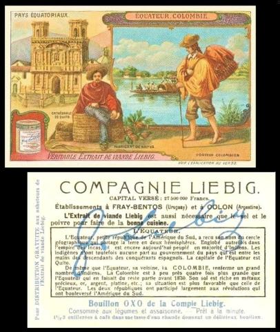
This card was chosen because it shows both Colombia and Ecuador, though in reverse order. The set was issued in Dutch and French, and the cards, in the French version, are
- Afrique Anglaise
- Borneo
- Bresil [Brazil]
- Congo
- Equateur, Colombie [Ecuador, Colombia]
- Sumatra
Many of these countries are the same name in the French and Dutch versions, the exceptions probably being our card, of Ecuador and Colombia, which are the same in Dutch but different in French, and Brasil, which in Dutch is Brazilie. However without seeing the cards I cannot be sure.
There is also a question about the set title for in the Dutch version that may be Betaalt Equatoriaal. Again, maybe you can let us know if this is right.
The most interesting card of the six is the first one on the list, Afrique Anglaise, or English Africa, because this was not a single region, it included countries in the west of the continent (Gambia, the Gold Coast, Nigeria and Sierra Leone), some in the east (British East Africa) and others in the south (Rhodesia and South Africa). However, the card shows a Masai warrior, Lake Victoria, and Mount Kenya, which actually ties it down to British East Africa, later to become known as Kenya. So as this card was issued in 1912, it ought to have been titled for British East Africa, or, at that time, Afrique Orientale Britannique.