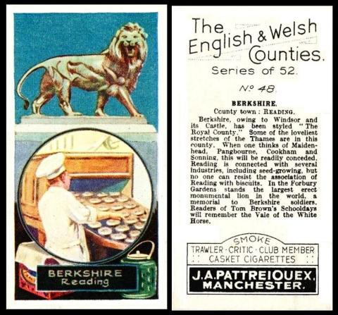
This is definitely one of my favourite sets, and today it is being used with good reason, for this card no only shows the town of Reading, but the circled image, denoting the main industry of that area, is a conveyor belt at a biscuit factory.
It would be most interesting if this image was proved conclusively to belong to Huntley and Palmers by someone magically finding this photograph, plus wording as to its location, in a contemporary magazine or newspaper. However I tend to think it is them. My reason for this is because if you look below the circle there are two brightly coloured biscuit tins, and the biscuit tin, as we learned earlier in the week, is not only mainly associated with Huntley and Palmers, of Reading.
Some time I will try to identify these very tins. However it will have to go on the bottom of a very long list of things to do. So if anyone out there is a tin specialist and would like to send us the names and model numbers of these tins, we would be most grateful.
Now this set is of fifty-two cards, an odd number, or so it may seem, but wait, for I have found a map, drawn up in 1928, the same year this set was issued, and it shows the counties of England, forty of them, plus the counties of Wales, twelve of them. That does make fifty two.
The counties on that map are as follows - but we have also added any changes, and the county town, in brackets, as they appear on the cards)
ENGLAND :
- Bedfordshire (Bedford)
- Berkshire (Reading)
- Buckinghamshire (Aylesbury)
- Cambridgeshire (Cambridge)
- Cheshire (Chester)
- Cornwall (Bodmin)
- Cumberland (Carlisle)
- Derbyshire (Derby)
- Devonshire (Exeter)
- Dorsetshire ("Dorset" - Dorchester)
- Durham (Durham)
- Essex (Chelmsford)
- Gloucestershire (Gloucester)
- Hampshire (Winchester)
- Herefordshire (Hereford)
- Hertfordshire (Hertford)
- Huntingdonshire (Huntingdon)
- Kent (Maidstone)
- Lancashire (Lancaster)
- Leicestershire (Leicester)
- Lincolnshire (Lincoln)
- Middlesex (Brentford)
- Monmouthshire (Monmouth)
- Norfolk (Norwich)
- Northamptonshire (Northampton)
- Northumberland (Alnwick)
- Nottinghamshire (Nottingham)
- Oxfordshire (Oxford)
- Rutlandshire (Oakham)
- Shropshire (Shrewsbury)
- Somersetshire (Taunton)
- Staffordshire (Stafford)
- Surrey (Guildford)
- Suffolk (Ipswich)
- Sussex (Lewes)
- Warwickshire (Warwick)
- Westmoreland ("Westmorelandshire" - Appleby)
- Wiltshire (Salisbury)
- Worcestershire (Worcester)
- Yorkshire (York)
Two differences here - Westmorelandshire appearing on the card, whilst the map halts at simply Westmoreland - and Dorset appearing on the card, though on the map the "shire" is added.
WALES
- Anglesey (Beaumaris)
- Brecknockshire ("Brecknock" - Brecon)
- Cardiganshire (Cardigan)
- Carmarthenshire (Carmarthen)
- Carnarvonshire (Carnarvon)
- Denbighshire (Denbigh)
- Flintshire (Flint)
- Glamorganshire (Cardiff)
- Merionethshire (Bala)
- Montgomeryshire (Montgomery)
- Pembrokeshire (Pembroke)
- Radnorshire (Presteign)
Here the odd man out is Brecknock, the "shire" on the map is missing.
There is something else strange though, because the county town of Radnorshire is shown as Presteign. Now the first problem there is that Presteign ought to have an e on the end, and read Presteigne. The second problem is even odder, as Presteigne was only the county town of Radnorshire until 1889. After that it moved to Llandrindod Wells.