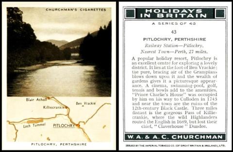
Now just in case anyone has been inspired by the details we have provided over this week about the Pitlochry Highland Games, our final card shows a map, albeit rudimentary, of how to get there.
Pitlochry was remodelled into a tourist resort because, in 1842, Queen Victoria and Prince Albert visited the area, and loved it so much they bought a house, Balmoral. This led to many visitors in the summer months, and to the building of a railway station in 1863. However there had been occupation in the area for many centuries earlier, and the Parish of Moulin takes its name from Moulin kirk, a fortified dwelling place which was given to Dunfermline Abbey in 1180 - though Moulin in French, and many other languages, seems to point to a windmill, not a house.
Tourism was still its major occupation until after the Second World War, and then it was decided to build a hydro electric power scheme along the River Tummel. As part of the works, they also needed a dam, hence the construction of an artificial loch, and the flooding of the original site of the Pitlochry Highland Games, north of the town, as we mentioned earlier in the week. Therefore it is rather a shame that this map was not more detailed, as we could have seen that original site on it.
Now I have more light, and better vision, I also have the original Churchman reference book (RB.10, issued in 1948). And there is a bit of a surprise, because there were actually five versions of this set. As this is the earliest version of the five, it wins the prize for being the home page, to which all the other versions will be connected through links. However along with that honour comes the delight of having the entire text for all the versions below. So let us start with that original Churchman reference book, which catalogues them as ;
66. May 1937. 48. HOLIDAYS IN BRITAIN. (titled series). Size 2 7/10" x 2 1/10" or 68 x 53 m/m. Numbered 1/48. Views, with brief map of district. Fronts printed by letterpress, half tone in two printings, in sepia, varnished. Backs in dark green on WHITE card, with descriptions and I.T.C. Clause. Printed by Mardon, Son & Hall.
67. 48. HOLIDAYS IN BRITAIN. Identical to (66) but CREAM card.
68. 48. HOLIDAYS IN BRITAIN. Identical to (66) but omitting I.T.C. Clause. Overseas issue.
69. June 1938. 48. HOLIDAYS IN BRITAIN. (titled series). Size 2 7/10" x 2 1/10" or 68 x 53 m/m. Numbered 1/48. Views, no maps. Fronts printed by 4-colour half tone process. Backs in dark green, with descriptions, album clause, and I.T.C. Clause. Printed by Mardon, Son & Hall.
70. 48. HOLIDAYS IN BRITAIN. Identical to (69) but omitting album and I.T.C. Clause. Overseas issue.
This is drastically reduced in our original World Tobacco Issues Index, and also they are split up - Section 2, "Issues with I.T.C. Clause" containing just :
HOLIDAYS IN BRITAIN. Md. Views and Maps. Sepia. Nd. (48) ... C82-51
HOLIDAYS IN BRITAIN. Md. Views only. Coloured. Nd. (48) ... C82-52
The export issues appear in Section 3, with more information in the header, as :
3. Export Issues without I.T.C. Clause.Issued 1937-39 through B.A.T. in Channel Islands, Malta, and British Garrisons overseas. All series are similar to the corresponding Home Issue under Section 2.B
HOLIDAYS IN BRITAIN. Md. Views and Maps. Sepia. Nd. (48) ... C82-94
HOLIDAYS IN BRITAIN. Md. Views only. Coloured. Nd. (48) ... C82-95
All this text is the same in our updated World Tobacco Issues Index, (though the codes have changed - to C504-505 and C504-510 respectively for the Home Issues, and C504-740 and C504-750 for the export ones. Curiously there is no link to section 3 from section 2, or any mention of there being export issues in any of those books. Casual browsers may, therefore, miss these overseas versions entirely.
Now you may be wondering why this set was printed more than once. At which point we also need to say that the two main versions, with and without the maps, were all new scenes and different places - card 43 in the view set being Ben Nevis, Inverness-shire. The truth is that we do not really know why this was done. The popular thought is that the sepia maps were thought to be old fashioned as we neared the end of the 1930s. Though I definitely favour the fact that this set was replaced because the Second World War was looming fast, and cards with maps may well have been used by the other side in the event of an invasion
